10 of South Africa’s Beautiful Landscapes
South Africa is a multi-ethnic society otherwise known as the rainbow nation as it encompasses a wide variety of cultures, languages, religions and races. Our pluralistic makeup is reflected in the constitution’s recognition of 11 official languages, which is among the highest number of any country in the world. It also cradles the most beautiful scenic landscapes of the world, with one of the Seven Wonders of the World being Cape Town’s Table Mountain; it has many more aesthetically seductive and majestic surroundings from dry harsh land, through beautiful plant life and to serene waters. Here are 10 of some of our country’s awesome landscapes.
The Wolfberg Arch In The Cedarberg, Western Cape
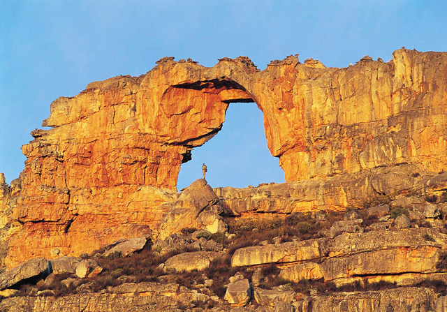
Photo by Lanz von Hörsten
The Cederberg Mountains are home to dramatic sandstone formations like the Maltese Cross and rich plant and animal life. These mountains are a great destination for rock climbers, hikers and those interested in rock art. The Cederberg Mountains are noted for their dramatic, wind-carved sandstone formations like the Maltese Cross and the Wolfberg Arch, as well as San rock paintings.
Misty morning in the Hex River Valley, Western Cape
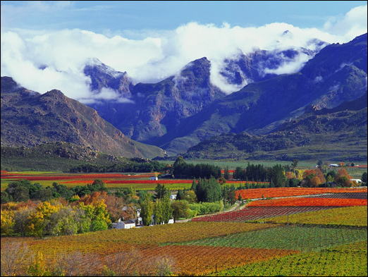
Photo by Hein von Hörsten
The Hex River Mountains make up the second highest mountain range in the Western Cape province and are located 120 kilometres north-east of Cape Town. They form part of a large anticline in the Cape Fold Belt mountain system and form a north-east, south-west trending mountain system forming the core of the Cape Syntaxes between the towns of Worcester and De Doorns. They are mostly composed of Table Mountain sandstone and most peaks reach 2,000 metres in height or more. The highest mountain is Matroosberg at 2,249 metres, making it the second tallest peak in the province after Seweweekspoort Peak in the Swartberg Mountain Range.
The bridge in Wilderness National Park, Western Cape.
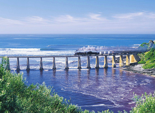
Photo by Neil Austin
Wilderness National Park is situated in the heart of the Garden Route, South Africa. It is a fascinating combination of rivers, lakes, estuaries and beaches, unfolding against the backdrop or lush forests and imposing mountains. During spring, the area is beautifully blanketed by a kaleidoscope of colourful blossoms, further enhancing its profound beauty.
Alexandria Dune Field, Addo Elephant Park, Eastern Cape
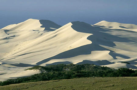
These extensive dunefields cover 142 square kilometers of ground, with some dunes being 2.5 kilometers wide and up to 140 meters high. Alexandria Dunefield is a reserve on the Sunshine Coast, Eastern Cape, that is privately owned by a family who has been farming chicory and livestock here since 1899. Some Dunes are lush with vegetation while others lie bare. Amongst these massive mounds are many pockets of bushes that are home to small animals such as the Dune Gerbil which is endemic to South Africa and the Bush Pig, which can be spotted darting around.
A Shipwreck At Agulhas National Park, Western Cape
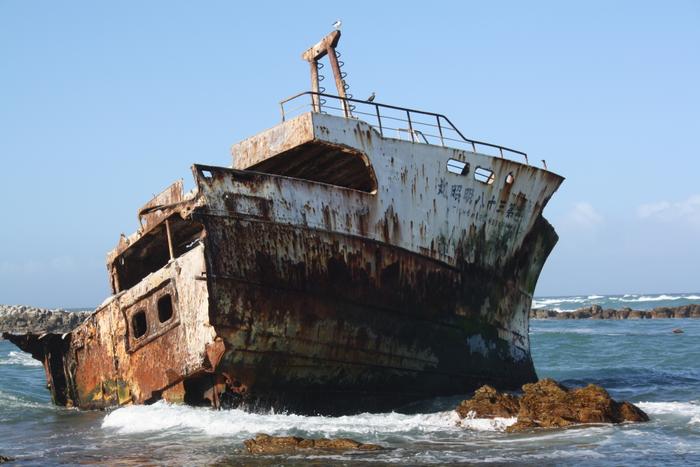
Most people drive through the Agulhas National Park on their way to Cape Agulhas, the southernmost tip of Africa. The second oldest lighthouse in South Africa was built here in 1848, an exclamation mark at the continent’s tip. The Agulhas lighthouse offers stunning views of this gently rounded coastal peninsula and even though this area is still in the process of being developed as a national park, it already attracts birders, beach-lovers, amateur botanists interested in the pristine fynbos, and anyone who loves a good shipwreck story. There’s a shipwreck for every kilometre of coastline here.
Mbhashe River, Eastern Cape
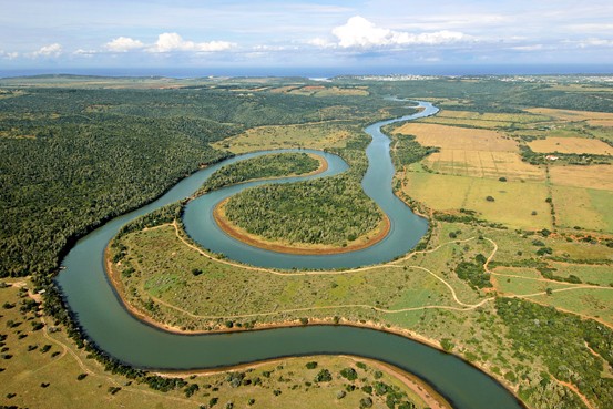
Mbashe River or Bashee River is one of the major rivers in the Eastern Cape Province, South Africa. It flows in a southeastern direction and has a catchment area of 6,030 km². The river drains into the Indian Ocean through an estuary located near the lighthouse at Bashee, south of Mhlanganisweni. The Mbhashe River’s main tributaries are the Xuka River, Mgwali River, Dutywa River and the Mnyolo River. Presently this river is part of the Mzimvubu to Keiskamma Water Management Area.
North West And Its Sunflowers
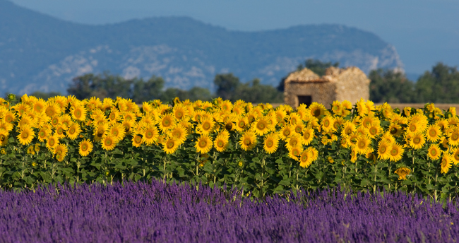
Forming the southern part of the Kalahari Desert the North West Province offers almost year-round sunshine, making suntan lotion and a hat a prerequisite when visiting the North West Province, South Africa. The capital city, Mafikeng, enjoys weather indicative of largely the entire North West Province, with towns in the western areas only slightly hotter and those further south a bit cooler. This province is famous for its corn and sunflower fields which are aesthetically pleasing while driving past at sunset.
The Orlando Cooling Towers
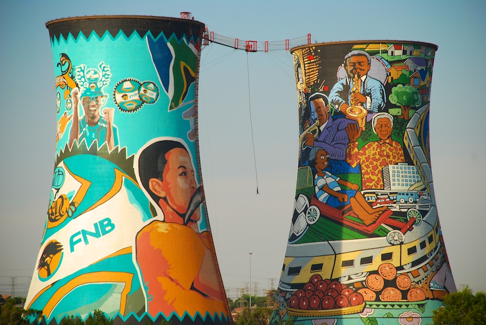
The two cooling towers are a prominent landmark in Soweto. They were built in 1951 to replace the spray pond cooling system used up to that time.Being supplied by sewage effluent from the Klipspruit Sewage Works, the spray ponds at Orlando were the first in South Africa to make use of this ready supply of coolant liquid.Both towers are painted, one functioning as an advertising billboard and the other containing the largest mural painting in South Africa.[6] The towers are also used for bungee and BASE jumping from a platform between the top of the two towers as well as a bungee swing into one of the towers.
The Big Hole
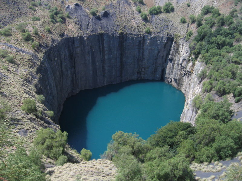
A trip to the Northern Cape Province would be incomplete without a detour to include the Big Hole in Kimberley; it is an opportunity not to be missed. What began as a flat-topped hill is today a gaping hole measuring 215 metres deep, with a surface area of 17 hectares and a perimeter of 1.6 kilometres. What makes Kimberley’s Big Hole that much more interesting is that it is an entirely man-made structure; the largest hand-dug excavation in the world.
The Three Rondavels
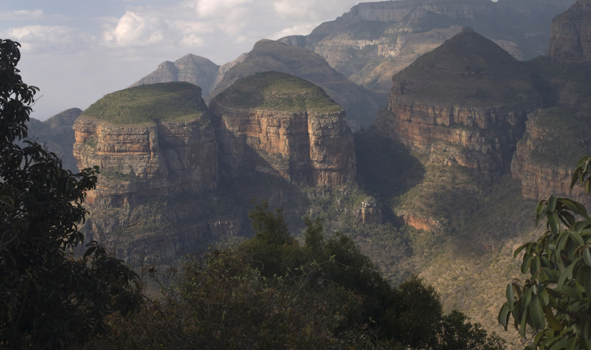
Along with Bourke’s Luck Potholes, the Three Rondavels are one of the major icons of the Mpumalanga Province. Both geological wonders are on the Panorama Route, a highly popular tourist drive to follow when exploring the province, and, depending on which way you choose to drive along the 16 kilometres of the Blyde River Canyon, the Three Rondavels either starts or ends your journey. Exactly as they sound, the Three Rondavels are three round mountain tops with slightly pointed tops, very similar to the traditional round or oval African homesteads made with local materials called rondavels. They are sometimes also called the Three Sisters.
photographs courtesy of South Africa National Parks and South Africa Info